


Public Campground
12.4 Mile Camp
Page, Arizona
Campground in Arizona.


Photos shown are stock images and may not represent the actual campground.
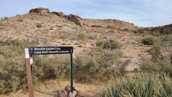
Ascending into the southern end of the Cerbat Mountains, Badger Trail meanders through scenic Mohave Desert vegetation and interesting granitic rock outcroppings. The route gains almost 1,100 feet in elevation over its 3.2-mile length and connects with Castle Rock Trail at the terminus. With a consistent 8 percent grade, this trail is moderately strenuous to hike or bike.At several locations along the trail, visitors can enjoy spectacular views of the surrounding valleys and mountains. Intriguin
Rating
Reviews
Kingman is popular during peak season. Reserve 2-4 weeks in advance for weekends and holidays.
Most parks have check-in after 1:00 PM and check-out by 11:00 AM. Call ahead if you'll arrive late.
Arizona weather can change quickly. Pack layers and check the forecast for Kingman.
Don't miss local attractions near Kingman. Ask the camp host for hidden gems and trails.
Mar 18, 2026
Badger trail is a well maintained and scenic trail. I went here on an early Saturday morning late October. I took the trail all the way to Castle Rock Peak. Not sure how accurate the posted trail mileage is to the peak, but according to my phone it was over two miles more round trip. The elevation climb is around 1,150 feet and some great views all around. This trail meets up with Castle Rock Trai... Badger trail is a well maintained and scenic trail. I went here on an early Saturday morning late October. I took the trail all the way to Castle Rock Peak. Not sure how accurate the posted trail mileage is to the peak, but according to my phone it was over two miles more round trip. The elevation climb is around 1,150 feet and some great views all around. This trail meets up with Castle Rock Trail and Sidewinder Trail, both of which tie into Beal Loop Trail and that can get you over to Monolith Gardens by going under the highway. So plenty of options. Bring plenty of water and sturdy shoes. You can only reach the parking area from North bound 93.
Mar 18, 2026
Great trail! Nicely maintained, easy to follow, and the switch backs make the climb more manageable. Definitely worth the view. Not sure why they say only open on Monday, it's open all the time. Wouldn't do with weather above 95° no shade of course.
Mar 18, 2026
Great Trail. If you can, download the Avenza app to get a free trail map. There's some elevation gain, but it's all gradual. Great views of the Haulapais and Golden Valley
Mar 18, 2026
The views from this trail are magnificent. Next time we'll take the time to go the extra little bit to the top of Castle Rock. It's pet-friendly however, keep an eye on them as there are very sharp pokies on the trail from one of the common cacti there.
Mar 18, 2026
Beautiful trails that wind up the hills and mountains. A lot of quartz stones all over and the views will not disappoint!
Mar 18, 2026
This was such a great little hike! There wasn't a bunch of people so we had a lot of time to ourselves. It was a short walk to the petroglyphs and the Agua Fria river. There's quite a bit of rock scrambling around the river then it opens up to a sandy spot before more bugs rocks. Bring lots of water and a hat, as there isn't any shade. Wear some water shoes also. There's several spots where you'll... This was such a great little hike! There wasn't a bunch of people so we had a lot of time to ourselves. It was a short walk to the petroglyphs and the Agua Fria river. There's quite a bit of rock scrambling around the river then it opens up to a sandy spot before more bugs rocks. Bring lots of water and a hat, as there isn't any shade. Wear some water shoes also. There's several spots where you'll cross through the water.
Mar 18, 2026
A short walk to an unexpected oasis with an interesting canyon to explore and a lot of wildlife to photograph. Bring water shoes for an extended adventure!
Mar 18, 2026
Beautiful scenery. The springs are flowing with crystal clear water. Enjoyed getting to see the petroglyphs.
Mar 18, 2026
Very easy flat sandy trail. About a half to 3/4 mile from the trailhead to the end ( its out and back.) Petroglyphs on the rocks at the end...they will be on your left
Mar 18, 2026
It was my first hike in Arizona and the desert. Very moderate trail to walk with some spots being even and flat to narrow. No water in the river allowed us to go up and along the creek bed and see some beautiful views and rock formations with spots to sit on the boulders and take it in and have reflection moments.
Claim this listing for free to update info, respond to reviews, add real photos, and start accepting online bookings.
Your RV Park Expert
Howdy! I'm Ranger Rex, your RV park expert. Ask me anything about campgrounds, state parks, national parks, or planning your next adventure!
Powered by AI · Responses may not be 100% accurate
