Photos shown are stock images and may not represent the actual campground.
About Margies Cove West Trailhead
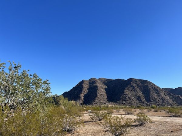
Margies Cove Trail is a near level, 9-mile route through the heart of the 63,200-acre North Maricopa Mountains Wilderness in the Sonoran Desert National Monument. Margies Cove Trail follows a combination of former vehicle tracks and wide, unmarked desert washes. The trail ends at the Margies Cove East Trailhead.Margies Cove West Trailhead includes day-use parking for ten vehicles, a campground featuring three campsites with picnic tables and steel fire rings, a vault toilet, and informa
Margies Cove Trail is a near level, 9-mile route through the heart of the 63,200-acre North Maricopa Mountains Wilderness in the Sonoran Desert National Monument. Margies Cove Trail follows a combination of former vehicle tracks and wide, unmarked desert washes. The trail ends at the Margies Cove East Trailhead.Margies Cove West Trailhead includes day-use parking for ten vehicles, a campground featuring three campsites with picnic tables and steel fire rings, a vault toilet, and informational signage.No trail signage or directional markers are available along the route, so this trail is recommended only for experienced hikers skilled in reading topographic maps. Use the USGS 7.5 minute “Butterfield Pass, Ariz.” and “Cotton Center SE, Ariz.” topo maps. Margies Cove Trail intersects the northern terminus of the Brittlebush Trail in the interior of the North Maricopa Mountains Wilderness. Only hiking and equestrian use is allowed in wilderness under the Wilderness Act of 1964. Motorized vehicles and mountain bikes are prohibited in wilderness.The North Maricopa Mountains are a jumble of long ridges and isolated peaks separated by extensive, saguaro-studded bajadas and wide desert washes. Cholla, ocotillo, prickly pear, paloverde, ironwood, and Mexican jumping bean complement thick stands of saguaro to form classic Sonoran Desert vistas. Commonly seen wildlife includes desert mule deer, javelina, desert bighorn sheep, coyote, desert tortoise, and numerous varieties of lizards and birds.Hours and SeasonsTrail can be used year-round; however, it is recommended for use from November through April. At other times of the year, the trail is seldom used due to high temperatures.Summer temperatures may often reach 115 degrees. Wear a hat, long sleeve shirt, sunglasses, and sunscreen. Drink plenty of water!Features and ServicesDrinking Water: There is no drinking water available. Bring plenty of water.Toilets: Accessible vault toilet onsite.Pets: Service dogs are legally permitted anywhere that visitors can go. Pack out all waste.Your SafetyThis is a remote area and access roads are not maintained. Cell phones do not work in many areas of the monument.Heat and SunThe monument's elevation ranges from 1,000 to 4,400 feet (304-1,215 m), so summer is rough on visitors. It's best to enjoy the monument from late October to mid-April. If you are visiting in summer, take extra precautions to drink plenty of water, as temperatures may exceed 110°F (43°C). We recommend sunscreen, sunglasses and a hat. Weather forecastWaterBring all the water you will need. There is no drinking water available on the monument. Plan on drinking one gallon (4 liters) per person per day—more if you're engaged in strenuous activities.Your vehicleMake sure your gasoline tank is full, carry additional water and full-size spare tires in your vehicle, and make sure your vehicle is in good working condition. Winter is the most popular time to visit.WildlifeThe desert sun stirs up rattlesnakes and other reptiles as early as February.Flash floodsFlash floods caused by sudden storms can be dangerous in washes, so it is best to have a survival plan to prevent emergency situations. Have good maps with you and know how to use them.Border ConcernsThe southern part of the monument is a corridor for drug and human smugglers. Be alert for illegal activities and law enforcement operations.Respect and ProtectThe area is home to many species of wildlife. Please remember to practice outdoor ethics and recreate responsibly. Help us protect this unique environment by leaving no trace during your visit.Check for fire restrictions before your visit. Using exploding targets, fireworks, sky lanterns, tracer ammunition and other incendiary devices is prohibited on BLM-managed public land in Arizona.Report resource crimes including vandalism, dumping and suspicious activity at 1-800-637-9152.
Park Details
Tips & Tricks
Book Early
Gila Bend is popular during peak season. Reserve 2-4 weeks in advance for weekends and holidays.
Check-in Time
Most parks have check-in after 1:00 PM and check-out by 11:00 AM. Call ahead if you'll arrive late.
Local Weather
Arizona weather can change quickly. Pack layers and check the forecast for Gila Bend.
Explore the Area
Don't miss local attractions near Gila Bend. Ask the camp host for hidden gems and trails.